
A CTA Map for 2055
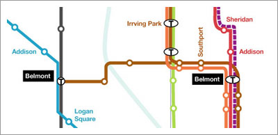
Proposed Roscoe Village Brown Line spur that would make my life approximately 1000 times easier
Craig Berman, author of the wonderful Fueled by Coffee blog, has a great piece up at Gaper’s Block. Using the CTA’s proposed Circle Line as a starting point, he meticulously outlines a subway plan for the future of Chicago.
The CTA needs to form a mass transit network — as opposed to the current radial commuter rail. Right now, all lines lead to the Loop in the morning and back out in the afternoon — these lines don’t take into account that a lot of living happens outside of the skyscrapers of the Loop. What happens when I want to get from Bucktown to Wrigleyville? Andersonville to the West Loop? Hyde Park to Pilsen? Little Village to Logan Square? These rides are a pain in the ass — they’re slow, indirect, and require multiple bus transfers. Why can’t you move from the North Side to the northWest Side without going downtown first? I want answers, dammit!
Amen, brother. Where do I sign up to help digging?
See also: Art of the subway
One response to “A CTA Map for 2055”
Hi, I’m John Tolva!
The Ampcamper
Views From The Tank

Full coralscape
The Terror Tourist
Latest: The Ghosts of Colorado
A roughly monthly essay on places in horror filmmaking — real or imagined, geographical or psychological — culled from The Heavy Leather Horror Show podcast.
Marginalia
-
What if the decline of Cahokia and over great cities of indigenous North Americans was a deliberate response to The Little Ice Age?
-
The religious right would claim this as existence of humans living during the time of dinosaurs.
-
Generative AI for participatory planning (by humans!)
-
I agree with this: “We’re all for ketchup — up to the age of decision,” Tom McGlade, then a spokesman and vice president for Vienna Beef, said in 2017.
-
Ring the bell to let the fish pass through the boat lock in Utrecht. This is what the Internet was made for.
-
"It seems to me that there is a fundamental discrepancy between the way readers interact with books and the way the hack-your-brain tech community does."
-
I'd watch a modern day Western flick based on this.
-
This fossil is 100 yards from my old house. A welcome friend on the walk to/from the L. (But it's a squirrel impression!)
-
How do you make sense of a world sloshing around in AI-generated content? The liberal arts.
-
Estimating the size of YouTube by "drunk dialing" URL strings.
-
Is it urban form itself that makes ghosts or the lack of community?
-
If they can pull this off in Phoenix, it can be done anywhere.
-
"Our universe's history, fossilized in light."
-
Thinking like Africa is a solution.
-
The hack that made my summer camper trip possible.
-
Live air traffic audio from the world's airports overlaid on ambient tunes.
-
See where any living thing exists in a beautiful interactive taxonomy visualization.
-
Flipping between channels of my childhood.
-
More impressive than tool-usage.
-
Type at work in the real world.
-
You're probably not prepared for how enthralling this is.
-
Anti-bird spikes as nest material, keeping other birds out!
-
B♭ C A♭ 8vb A♭ E♭.
-
Trains, automobiles, and rocket ships, basically.
-
"The act of simplifying reality for a machine results in a great deal of complexity for the human."
-
Sara Benincasa on the beauty of The Bear.
-
Two writers facing one Turing test: A dialog in honor of HAL between Richard Powers and Bruno LatourPrescience for our current world from 1998.
-
"History is the long process of outsourcing human ability in order to leverage more of it. We will concede this trivia game (after a very long run as champions), and find another in which, aided by our compounding prosthetics, we can excel in more powerful and ever more terrifying ways."
-
AI neologisms. Could just link #termsfromtoday to this and never manually post again.
-
Science fiction becomes reality for fossil literature.
-
So much worse than the passive voice.
-
AI-generated imagery in the service of mythopoeic storytelling on a small town scale. (Follow via Instagram.)
-
"Dark magic box": The unique design opportunity of designing a marine ecosystem experience for visitors.
-
"A book with feedback"
-
Matt Kirschenbaum writes his own words about the "ongoing planetary spam event."
-
Meaning isn't 100% transitive.
-
A one-shot music video performed using only the reel-to-reel tape recorders.
-
Just because it was inevitable doesn't mean it isn't glorious.
-
Dan makes me nostalgic for Twitter 2007-2013.
-
Incredible instrument made from two Commodore 64s, floppy disks, tape and a giant dose of nerdery.
-
‘Oh, that’s tennis for non-athletes.'
-
Answer: barely, with a few modifications.
-
Some behind-the-scenes of my work life.
-
The All Iowa Lawn Tennis Club!
-
"Hell's Aquarium"
-
"Before we rolled out through the gate, I’d tell myself that I didn’t need to worry, because I was already dead. The only thing that mattered was that I did my best to make sure everyone else came back alive."
-
"The problem wasn’t that Sisyphus had to roll his boulder up a hill forever; it’s that he had to roll it alone."
-
Same with me, clowns, same with me.
-
I'm here for the needless politicization of tennis versus pickeball.
-
Biomimicry meet reclaimed waste product.
-
"Cities are where we see each other. People who don’t want to see hate that."
-
How much do you know about lines?
-
Documentary on Minnesota's failed attempt at a city of the future in the late 1960's.
-
"Humanity, how are you doing on this beautiful Monday?"
-
Amazing visualization of European lighthouses showing light color, actual pattern, and radius of visibility.
-
An interesting data point, for sure, but this metric may be the best part: Stool Hardness and Transit (SHAT) score.
-
The exact time of day, pulled from books.
-
Einstein confirms.
-
Mapping magnetic fields to the audio spectrum.
-
So pretty you often don't stop to listen.
-
The greatest tribute ever penned by a child for a parent.
-
Humans walking through a city don't take the shortest route but the one that physically points them at their destination most consistently.
-
Placing this here to remind future me.
-
LIght pollution of course ruins this.
-
Clever. Would be even better using LEGO's bioplastic bricks.
-
It doesn’t solve the problem to buy a hybrid and retrofit your house if all of that takes place 20 miles from your job.
-
Eno on urban design is masterful.
-
Railroad marketing ploy. But it's still quite nice here.
-
Particularly proud of this project from the Colorado Smart Cities Alliance.
-
"'There is an Italian phrase,' said Marco after we ordered our food. '"Li ti avvelenano", which translates to "there they will poison you." This is my prediction for the night.'"
Thanks for the link… and get your shovel ready.