
When tech culture and urbanism collide
The city is the most complex machine ever invented. Running optimally the city generates opportunity and provides a platform for interaction, ideas, and improvement. As a concept the city has been iterated-upon, smashed and burnt to the ground, rebuilt, deliberately-designed, haphazardly-organized, and generally resilient for many millennia. But the city is still a human invention and every single one is flawed, many horribly so.
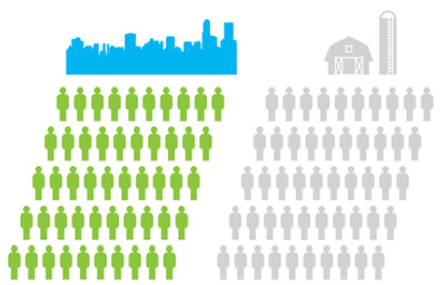
Which makes cities the ultimate problem set. For the engineering-minded and entrepreneurial the challenge of cities has enticed since the first itinerant merchants decided that they were no longer itinerant. Cities for centuries have been the locus of commerce and the crucible of invention (often from necessity). Demographically, they are on a path to be called home to 70% of the world’s population by 2050. If you want a market — or are driven by the moral imperative of figuring out how to get that many people to live in relative harmony — cities are your platform.
And yet some of our most creative problem-solvers — entrepreneurs and technologists who invent the things that have changed our lives radically over the last decade — seem not to grasp what makes cities so dense with opportunity in the first place. There’s a disconnect between the culture of technology companies and what makes for smart urban policy.
Recently SPUR‘s Allison Arieff noted the ways that tech companies have enthusiastically co-opted the language of urbanism — “community”, “the commons”, “town halls”, etc — while not actually embracing any of what that means in the real world. “Why,” she asks, “are tech companies such bad urbanists?”
The answer is that suburbia is in the very DNA of Silicon Valley, which makes it part of the genome of tech culture writ large. Though many of the biggest companies in tech now are less than ten years old, Silicon Valley itself came to be during the boom of late-20th century car culture. (The garage itself is mythical in startup lore.) Anti-density land use, zoning laws that abet sprawl, work-life patterns fashioned around automobile commuting — these traits are as central to Silicon Valley as Stanford, libertarianism and foosball.
Tech headquarters in the Valley (and many other places) are built as simulacra of cities. Corporate campuses sport their own transit systems (some of which venture out into the city itself, altering socio-economics in their path), bike share systems, restaurants, and health clubs. Facebook’s HQ even has a faux downtown, something straight out of a 1980’s shopping mall design handbook. Unlike a mall, though, none of this is open to the public. While “community” may be the buzziest of words in tech parlance, this is community-as-facade, a highly engineered experience that still revolves around automobile commutes and forecloses true serendipity. It would be funny if it weren’t such a problem: For all their embrace of futurism, tech companies in the Valley are merely recapitulating the failures of a bygone age of suburbia.
And yet San Francisco is the preferred place to live for many of these employees. Which is great, except that their salaries — out of synch with the communities in which they live — generate an economic force that skews rents, forces evictions and creates class stratification driven almost entirely by corporations not located in the city. It’s the reverse of a bedroom community. Wealth drives people into cities while keeping the engines of that wealth outside the city.
But this is 2013, not 1960. Today’s tech companies are not stupid. They understand the benefits of the city from a business perspective. (Which is why Amazon, Twitter and Zappos are all building headquarters in the middle of cities.) It is where the talent lives, its many modes of transportation chime with companies’ commitment to the environment and employee health, and cities are very often the conceptual blueprint for social innovation on the web, as Arieff points out. But understanding the benefits of urban life and attempting to create them as self-contained units that simulate a city — as much of middle America did in the latter half of the 20th century with gated subdivisions, office parks, and shopping malls — are two very different things.
Which is more than odd; it’s contradictory. The web itself, fount of so much innovation in the tech world, is the network embodiment of density, diversity and proximity — precisely the characteristics of cities. The sidewalk was the original social network; the corner store the original just-in-time retailer; the town square the original blogging platform. Given this symbiosis one would think more of an effort would be made in tech circles to understand the precepts of urban design.
——
So how do we change this? What might we do to set the sights of our smartest technologists towards sustainable urban design?
A start would be to remind tech companies of one of their core principles: user-centered design. Understanding city life means living city life. Not just commuting to it or from it and certainly not believing you understand a person’s situation just because you pass him or her on the street from time to time. The best products are those that begin with a user’s motivation and needs. They are empathetic applications. To crack the nut of urban-scale opportunity — and there is a lot of it, just look at the “sharing economy” successes of Uber, Airbnb, and Zipcar — technology must be built amidst the same forces that create the problems it is trying to solve.
And those problems must be meaningful and relevant to cities, per se. Nine times out of ten the first image in an ad or a presentation on the subject of smart cities will be of a traffic jam — as if congestion were the number one problem facing the city. It’s a very suburban view of what an urban problem is.
Is the self-driving car really what our rapidly-urbanizing world needs? Every single one of our ballooning population in their own hermetic cocoons? That too is a suburban view of the problem, a moonshot to an uninhabitable moon.
Vibrant, safe public spaces; shared, multimodal streets; exemplary education systems that propel people from early childhood through post-secondary; affordable housing — these are the issues that make or break cities. Or, put another way, these are the problems worth solving because they are worth a lot. Yes, in economic terms. Venture capital is all about risk and return. That risk (and potential incredible reward) is splayed out in every city in America.
To read certain of the screeds against the city (and responses to Arieff’s column) you’d think no entrepreneur or developer was having any success tackling urban opportunities. But that’s simply not true. We can build upon the success of the work being done at the intersection of technology and urban design, right now.
For one, the whole realm of social enterprise — for-profit startups that seek to solve real social problems — has a huge overlap with urban issues. Impact Engine in Chicago, for instance, is an accelerator squarely focused on meaningful change and profitable businesses. One of their companies, Civic Artworks, has set as its goal rebalancing the community planning process.
The Code for America Accelerator and Tumml, both located in San Francisco, morph the concept of social innovation into civic/urban innovation. The companies nurtured by CfA and Tumml are filled with technologists and urbanists working together to create profitable businesses. Like WorkHands, a kind of LinkedIn for blue collar trades. Would something like this work outside a city? Maybe. Are its effects outsized and scale-ready in a city? Absolutely. That’s the opportunity in urban innovation.
Scale is what powers the sharing economy and it thrives because of the density and proximity of cities. In fact, shared resources at critical density is one of the only good definitions for what a city is. It’s natural that entrepreneurs have overlaid technology on this basic fact of urban life to amplify its effects. Would TaskRabbit, Hailo or LiquidSpace exist in suburbia? Probably, but their effects would be minuscule and investors would get restless. The city in this regard is the platform upon which sharing economy companies prosper. More importantly, companies like this change the way the city is used. It’s not urban planning, but it is urban (re)design and it makes a difference.
A twist that many in the tech sector who complain about cities often miss is that change in a city is not the same thing as change in city government. Obviously they are deeply intertwined; change is mighty hard when it is done at cross-purposes with government leadership. But it happens all the time. Non-government actors — foundations, non-profits, architecture and urban planning firms, real estate developers, construction companies — contribute massively to the shape and health of our cities.
Often this contribution is powered through policies of open data publication by municipal governments. Open data is the raw material of a city, the vital signs of what has happened there, what is happening right now, and the deep pool of patterns for what might happen next.
Kicked off by data.gov and data.gov.uk, the open data movement has been replicated in most major Western cities. There’s no doubt this data has been put to good use by people and organizations outside of government. Chicago’s ecosystem of “civic hackers”, for instance, is unparalleled, generating hundreds of applications and analyses that make the lives of Chicagoans better. School data, lobbyist data, foreclosure, zoning and land use data, health atlases, snowplow-tracking data, real-time transit data, incarceration data, food-borne illness data — all these sets have been usefully translated into applications that change the way the city is used.
Tech entrepreneurs would do well to look at the organizations and companies capitalizing on this data as the real change agents, not government itself. Even the data in many cases is generated outside government. Citizens often do the most interesting data-gathering, with tools like LocalData. The most exciting thing happening at the intersection of technology and cities today — what really makes them “smart” — is what is happening at the periphery of city government. It’s easy to belly-ache about government and certainly there are administrations that to do not make data public (or shut it down), but tech companies who are truly interested in city change should know that there are plenty of examples of how to start up and do it.
And yet, the somewhat staid world of architecture and urban-scale design presents the most opportunity to a tech community interested in real urban change. While technology obviously plays a role in urban planning — 3D visual design tools like Revit and mapping services like ArcGIS are foundational for all modern firms — data analytics as a serious input to design matters has only been used in specialized (mostly energy efficiency) scenarios. Where are the predictive analytics, the holistic models, the software-as-a-service providers for the brave new world of urban informatics and The Internet of Things? Technologists, it’s our move.
Something’s amiss When some city governments — rarely the vanguard in technological innovation — have more sophisticated tools for data-driven decision-making than the private sector firms who design the city. But some understand the opportunity. Vannevar Technology is working on it, as is Synthicity. There’s plenty of room for the most positive aspects of tech culture to remake the profession of urban planning itself. (Look to NYU’s Center for Urban Science and Progress and the University of Chicago’s Urban Center for Computation and Data for leadership in this space.)
And what about the built things themselves, actual physical architecture? Where is the technology that causes us to rethink our domiciles and places of work, recreation and worship in the ways we’ve remade communications, mobility, and manufacturing in the last decade? Where are the tools that make urban districts as responsive to changing uses as metal and glass have been made malleable by 3D design tools? Where, to put it most like a William Gibson novel, is the “architecture that flickers and buzzes like faulty neon, that is washed with intermittent static like a weak video signal”?
Architect Doris Sung, for example, has begun experimenting with materials that change shape based on external stimuli, much like human skin. And it’s not just materials science, but high technology as well: the increasing instrumentation of cities with sensors and actuators creates a literal platform for designing new experiences. This is what technology startups in particular are good at.
——
Scientists have a term called “positive suboptimality” which refers to the resilience of systems which are not specialized for a particular use (or which at least weather changes in external conditions without breaking). Most often this concept is used to describe how nature has evolved not with the fittest organisms but with those fit enough to survive changing conditions. Super-specialization means extinction.
It’s a concept that could usefully be applied to cities. Precisely the way cities fall short of perfection is what gives them resilience and opens up opportunity where none previously existed. What appears broken and yet persists in cities may simply be evidence of fault-tolerance, something all technologists strive for with their products.
Molly Turner nails why this so rubs some technologists the wrong way:
[T]ech innovators also like to work on a tabula raza, void of constraints, preconceived obstacles or even the benefit of institutional knowledge. And while sometimes that leads to genius strokes of ingenuity, other times it means unknowingly repeating mistakes of our urbanist past, such as becoming overly reliant on the wisdom of the crowd or failing to account for important social or cultural divides.
Understanding how cities bend but don’t break, understanding how they do indeed break, and understanding how much of where we live influences the solutions we try to fit to problems are the greatest lessons that tech can take from urbanism.
City officials are often asked “how do you turn this place into the next Silicon Valley”? Most smart folks in economic development answer by saying that they don’t want to. They want their city to capitalize on its own legacy, assets, work ethic and skills. For many years that statement was just politicking and boosterism. But it isn’t anymore. Cities are where the problems exist and where the talent is moving. It’s easy to see how this equation sums and time for tech culture to do the math.
What the public way means in the networked age
Let’s start here. I want our relationship with public objects to feel like this.

It does not feel like this currently.
But let’s back up to a street scene in Chicago in the late 1930’s for context.
You’re walking at a clip downtown because it’s storming. You hunch over and tilt your umbrella into the sheeting rain as people scamper for cover and taxis. Luckily your destination is this building and you know, thanks to having walked this route before (and a clever architect), that you don’t even have to look up to figure out that you’ve arrived.
On both the Clark and LaSalle sides of the Field Building (as it was originally known) are symbols in the sidewalk pointing to the entrances. F for Field, arrows for which way to turn.

If noticed at all, these small, plain sidewalk icons could easily be mistaken for architectural decoration. But they were designed specifically around the umbrella use-case.
You may also have seen compass markings in the sidewalk just as you step out of a subway stop. Easy to overlook, but incredibly useful if you’re disoriented emerging onto the surface grid.
These examples represent embedded, passive information that’s not screaming for attention but placed precisely where you might need it. It’s information design in the physical architecture of the public way.
Today there’s a new usage scenario. You’ve seen it a thousand times. Urban pedestrians staring down at their smartphones, half-in and half-out of the moment in what Amber Case calls “temporarily negotiated private space”.
Maybe the F-marks would be missed by these otherwise engrossed city-goers, but they are a great example of ambient information in city environments. And we’re going to need a lot more of that as we increasingly negotiate our public space through a mixture of physical and digital awareness.
What’s new is the sheer volume of mobile, networked technology in our public spaces (and everywhere else). It’s an opportunity to “embed” information in new ways and to customize it to very specific places and moments in time.
Typically sensors and wireless connectivity claim the spotlight in discussions of the networked city, but I’d argue we’re missing a real opportunity not to use new technology to make the built environment more legible.
Why?
Most obviously, embedded digital information can aid in safety. The video of the girl in China on the phone falling through the sidewalk is one end of a spectrum of examples, most of which are instances of obliviously texting pedestrians falling off piers, walking into traffic, or smashing into one another. And it’s probably getting worse.
Rudimentary systems that might prevent such calamity do exist, but with a focus on motorist, rather than pedestrian, alertness at crosswalks. Crosswalks and Xwalk both flash lights to make the zebra stripes more prominent. You could imagine a more nuanced system which assumes pedestrians are looking down (at their devices) and flashes or changes color when the traffic signal is about to turn green. Interaction with devices via Bluetooth or NFC is not inconceivable either. Scenario: if the device is engaged in use, assume distraction, and alert accordingly. A responsive public way that’s in a positive feedback loop with its users.
Accessibility is another category of use for the responsive public way. Crosswalk design for the visually-impaired is not a problem for individual intersections — high-pitched chirping signals — but it doesn’t scale for large cities. The cacophony of a city full of bleating traffic signals would be the kind of noise pollution that causes New York City to impose fines on honking motorists. But if the crosswalk itself was open to digital development you could imagine white canes, phones or other personal devices alerting the visually-impaired pedestrian that the street was open to cross.
Basic convenience may be an even better rationale for a legible (and writable) public way. Why perform a digital transaction at a modern-day parking meter when you can text it or use an app to pay before leaving your car? Think driving snowstorm. Think having three kids in the backseat and the meter is 100 meters away. Think not having a credit card at all. All good reasons. This is getting closer to the high-five moment of a digital public way.
If we begin to think of a truly responsive public way we have to rethink what “public” means in the digital age. The analogy here is a city’s information. Getting at a city’s vital signs and the records of public servants has been a long slog for transparency advocates. In the days of exclusively paper-based record-keeping Freedom of Information legislation was one of the only ways to do anything with public records. Then came digitization and the same barriers obtained. You had to go through legal maneuvers to get at it — and even then it was not particularly useful beyond reading it. PDF’s largely made this information static, opaque to computer-aided parsing and tabulation. But the advent of machine-readable online document standards and a shifting political climate towards the value of open government has unlocked torrents of data in cities around the world. What’s come of this can only be described as a new kind of civic engagement: open data has bred an ecosystem of secondary applications, analysis, and interactions that governments could never conceive of, much less produce themselves.
The infrastructure and objects of our current public way are in their paper period.
Certainly, there are screens scattered throughout. Public transit leads the way here. Buses that generate location data, subway platforms that announce arrival times, etc. There’s some digital marketing along the way that occasionally serves up alerts or public service announcements. And every so often you’ll see an advertiser attempt something (barely) interactive — a QR code for more information, typically. But there’s no platform in the software and open data API sense of the word in the physical city.
And yet, many of our public objects are networked — the foundational requirement for a responsive system. Public bikes and bike stations, bus shelters, parking meters, and of course every light pole with a public access point clamped to it — all these things are network endpoints. But they’re not interconnected and they are not open to interaction. There’s no interface for third-party development.
Some City of Chicago Department of Transportation construction projects feature NFC and QR codes on signage onsite that link to information about the project. That’s the paper stage, incunabula. The vision is for direct access to mobile-optimized applications for business permits in situ. More promisingly, the information system underlying the upcoming roll-out of public bike sharing in Chicago (e.g., real-time bike availability info) has an open API. 4,000 bikes and 400 stations will be open to development and interaction in the way that the city’s open data portal is. A step away from paper towards platform.
There’s an inverse to this dynamic, equally ripe with opportunity. The impact of city-dwellers’ use of digital technology when out-and-about has yet to make a any real impact on physical urban design. Mayor Nutter of Philadelphia got a good laugh last year when he released an April Fools Day video touting newly-striped “texting lanes” on sidewalks. But that was parody (though thinking about it a little longer makes it slightly less parodic).
Surpassingly few cities and urban design firms actually give thought to how technology is changing the way the city is used. Which is odd, since so many of the problems that online companies grapple with — what it takes to create a vibrant, safe public space, as one example — have pretty well been solved, if not perfected in implementation. There’s the Facebook approach, which is essentially suburbia: a gated network of affinity that disallows chance encounter and serendipity. And there’s the Twitter approach which is all about non-reciprocal engagement and diversity. (It’s no coincidence that the founder of Twitter is a dilettante urbanist.) This is a choice between mall culture and real urbanism and I fear that our information architects and built environment architects have not even begun the conversation.
The sidewalk is the original social network and its lessons have much to teach the designers of our digital overlay of public spaces.
In Chicago, it’s coming together: a robust open government community of engaged developers (and increasingly savvy residents) fueled by an administration actively publishing data and working to make sure the vendors of our public objects treat it as a platform. There’s a long way to go, but we’ve etched some symbols in the pavement and we’re hoping you follow our lead.
High five!
Welcome to City Forward
“I felt the physical city to be a perfect equation for a great abstraction.”
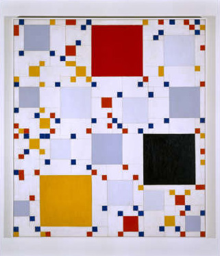
Homage to Victory Boogie Woogie #1, Leon Smith
It’s hard not to see the reasoning behind that quote from the Mondrian-acolyte painter Leon Polk Smith when you learn that he grew up amidst the gridded fields of Oklahoma before moving to New York City.
But it’s instructive in another way. The physical city certainly is the expression of abstract things. The desires of its inhabitants, the collective aesthetic of cultures, the movement of goods, the education, safety, and utilities that strengthen or weaken it.
What’s been missing is a good way to describe that equation. And that’s why I’m pleased to have been a part of the development of City Forward. This site is a first step in aggregating, visualizing, and socializing the abstract vital signs of cities worldwide to permit a better understanding of the world we live in. It’s rich with functionality — honed over many months with amazing feedback from our beta community — to provide a single place to work with the data our cities are opening up.
We’re not alone in this endeavor and we hope to play a critical role in the ecosystem of applications that are making public data more useful, insightful, and actionable.
City Forward has a lot to offer. I encourage you to learn more about what it can do (perhaps watch the video) and to create your own explorations of the data within. Help us find the equations so we can describe a better future for our metropolitan regions.
Lessons from unmaking urban mistakes
Over there, a woman’s walking down a city sidewalk.

She’s doing all kinds of things at once: walking, texting, presumably not being hit by a biker, even perhaps being stalked. Framing this in terms of interaction design, we might think of it as a moment of simultaneous navigation of multiple information interfaces. One of these interfaces is rarely thought of as such; it is the skin of the built world: the sidewalk, curbs, building entrances, shop windows, signage, and welter of moving elements (human and machine) that cross her path. Another is digital: the menus of an iPod, or an application on a smartphone, a GPS map, an SMS keyboard.
Thinking more deeply about only these two — the interface of the street and of her device — it’s clear we’re considering two highly designed modes of interaction. The first by architects and city planners, the second by computer engineers and UI designers. Millions of times a day in a single city these two interaction modalities are layered on top of one another. Now consider that the two communities of practice that develop these interfaces rarely interact, much less formally share knowledge or design in tandem. This is a problem, for both communities partake of city-making.
There aren’t many truly complex things the human race has been making longer than cities which is why it seems irresponsible to me that the participants in what Adam Greenfield calls read/write urbanism would not look to the historical record for insight — especially as we seek to learn from the mistakes we’ve made with the built environment.
But what does this actually mean?
Let’s use one example that currently enjoys a lot of debate and which has had a direct impact on the above pedestrian scenario: urban highways and the various movements to undo them.

A Transit Program For The Los Angeles Metropolitan Area, 1939
Planning for urban freeways in the first half of last century is often obscured by the white-hot glare of construction that followed from the US Federal Highway Act of 1956. Early 20th century designs emphasized intra-metropolitan mobility, supplementing the dense grid of cities with multiple interchanges, relatively small facilities, and overall attention to harmonizing with the urban fabric (as with multiple central parkways, in the map above). These early freeway designswere built to integrate holistically with other modes of transportation such as railways and bus lines and some even included land redevelopment as part of the construction plan. Because these plans grew from the city itself so, at this point, did the funding mechanism: property taxation, bonds, and special assessment districts (source: JAPA, “Planning for Cars in Cities,” Brown et al, 2009).
This mostly-local method of funding was not adequate to the scale of superhighway infrastructure being planned and so the trajectory of development followed a different course. With centralized funding from the federal Highway Act, itself fueled by new gasoline taxes, the engine of interstate highway construction roared to life. The arteries being built — call them vehicular broadband — eventually stretched through and into the nation’s cities, despite Eisenhower’s initial plan to terminate them at city limits. As the responsibility for construction fell to federal engineers with a different set of priorities than local city planners, nuanced integration of the highways with the urban landscape was largely forgotten.

Traffic on the Los Angeles Harbor Freeway, I-110, 1958
There was a lot to praise about the Interstate Highway System. High-speed transit and increased mobility changed the very culture of America, permitting easier mobility, increased opportunities for employment, and a broader discovery of the nation itself. But these highways had unintended consequences too. The demand for destinations along the highways induced a period of development that has led to sprawl, exurbia, and an entire class of highway-only development.
In urban areas the effects were compounded by the density of travelers, leading to congestion and pollution. Worst of all from the holistic perspective of the city, urban highways sliced through neighborhoods, disconnecting the human-scale interactions and pedestrian mobility that had defined the street-level vitality of city life. Urban highways often blighted, segregated, or simply erased communities while creating both a physical and psychological barrier to local movement.
By the end of the 20th century some municipalities had come to understand the adverse consequences of urban highways. Portland led the way in 1974 with the demolition of its Harbor Drive Freeway. Other highway removals or reroutings included the West Side Elevated Highway in NYC (after a collapse and contentious public debate), the Park East Freeway in Milwaukee, the Embarcadero Freeway in SF, and most famously the burying of the I-93 highway in Boston known as the Big Dig.
Though all related to unmaking highways, these projects were the result of quite different initial circumstances, engineering approaches, and political machination. And yet each project was an attempt to undo damage done to the urban fabric, to correct a mistake. What might we learn from these examples as we consider the information architecture of cities?
(1) Unintended consequences accompany any design of a complex system.
It would be hard to argue that designers intended the linear parking lots that many of our city freeways have become. They simply did not understand the nature of induced demand: build it and they will come — at which point you’ll learn that you didn’t build it big enough. This is cyclic, congestion-abetting design, however unintended.
Yet I mean not to equate unintended here with negative — at least not entirely. Take the construction of I-93 through Boston’s central business district. There’s no doubt it rended the city in ways its still suffering from, but as the elevated roadway curved northwest at Atlantic Avenue it effectively created a wall between the North End, Boston’s oldest residential community. In important physical and psychological ways, the North End was preserved by this severing of the formerly continuous urban fabric. (While many in “urban renewal” circles saw the North End as blight to be removed, the publication of Jane Jacobs’ Death and Life of Great American Cities is credited with preventing it from being razed as Boston’s West End had been shortly before.)
The North End’s Little Italy neighborhood is arguably the most authentic in the US. The scale of interaction is utterly human, its streets and buildings echos of usage rather than overlaid standardization. One need only look to the Disneyfied Faneuil Hall marketplace just to the south to see what commercial development of a historic area could have meant for the North End. The urban freeway as an unintended factor in historic preservation.

Left: I-93 cutting through Boston's central business district. Right: The Rose Kennedy Greenway built atop the buried highway.
But I-93 has been buried and the barrier to pedestrian movement to the North End is mostly gone. And so is the barrier, perceived or real, to the forces of gentrification and large-scale development that characterize so many historic districts today. The consequences of this remain to be seen.
One might point out that high-performance computing today gives us the ability to model complex system dynamics, simulating possible outcomes of given decisions. But these are early days — and even if a truly comprehensive, responsive city simulation could chart the probability curves for every possible outcome we’ll always have to confront decisions that have implications for a future further out than we can currently predict. (Note that early supporters of the automobile in cities rested much of their argument on a very obvious environmental benefit: cars didn’t leave piles of poop in the street.)
So, while technology does not seem to offer short-term hope for predicting the unintended in complex systems, the invisible architecture of data and services does afford more nimble rearrangement and redeployment than do viaducts of concrete or steel girders, at least in theory.
Cities, of course, are a model of resilience. Buildings learn, the street finds a way, patterns of usage can be reshaped — albeit with the pace of a medium made of brick and mortar. In this way, but with far more speed and flexibility, the architecture of information and services in cities can be built not to prevent unintended outcomes but to enable them. If we agree that inadvertent outcomes are unavoidable in sufficiently complex systems such as cities, then the opportunity we’re presented with in matters of digital design — the lesson, so to say — is that extensibility should be a primary goal. It must, above all, encourage adaptation.

(2) Throughput is not connectivity.
The goals of the Interstate Highway System were simple enough: increased volume of movement at increased rates of speed with fewer accidents. (It is no coincidence that the frontispiece to the 1968 “The Freeway in the City” report to the Federal Highway Administration used this iconic 1909 photo of congestion at Dearborn and Randolph in Chicago.)
It seems likewise simple enough to note that vehicular broadband (a measure of volume-over-time) is not the same thing as mobile connectivity. Yet this misunderstanding — or willful blurring of two very different things — is the mulch from which so many problems with urban freeways grew. Plowing into the dense grid of local thoroughfares, superhighways sacrificed distributed human-scale connectivity of points A through Z for high throughput from point A to point B.
Cities have always been proto-internets of connection and interaction. There’s never only one way to arrive at a destination in a city; multiple routes make cities both diverse and fault-tolerant. But if we extend this analogy — or, rather, make it less of an analogy — to think of cities as information-processing machines, there are some fairly clear lessons to be drawn as we consider communications broadband and the larger implications it has for community connectivity.
Urban waterways, roads, and rail links are all networks of information as well as of goods. There’s value in these networks: information is moved, consumed, changed, combined and created. But there’s a finer level of detail too: at the human scale value is created by observation, being observed, and chance encounter. It’s a physical infrastructure that permits multiple channels of information flow — and this makes for a more efficient, diverse, and redundant system.

Diverse elements catalyze connections among themselves
In their excellent Information Architecture of Cities L. Andrew Coward and Nikos A. Salingaros make this point most forcefully, assigning the term “fractal loading” to the ability of a single channel (in this case a sidewalk) to carry multiple forms of interaction.
A primary information exchange is a pedestrian going from one point to another. He or she observes things that are unrelated to the primary reason for movement. This information is functional; it can recommend secondary behaviors to the observer who is executing a primary information exchange. A successful city is one in which even simple movements are a rich and rewarding experience. Urban space therefore works by violating the “functional” rule of twentieth-century planning. Successful urban geometry serves a multitude of needs on distinct scales; some strictly functional and others pleasurable.
Walking to an appointment in a European capital (indeed, in most of the world’s cities) can be more pleasant than a drive to achieve the same end in a North American metropolitan area. In the former case, one sees other people, some of whom one might wish to talk to; observing others may provide clues on social currents and interactions; window displays provide information on available products and services, etc….
Fractal loading has the crucial feature that removing the largest level of scale leaves all the other smaller levels of scale intact. Not having to execute a definite errand, undirected wandering in informationally-rich cities allows the visitor to accept recommendations offered by different visual environments, and to discover the results of such movement. It is thus possible to learn the rich and complex “visual language” of an unfamiliar city that has only changed gradually over hundreds of years. By contrast, in a non-fractal deterministic environment lacking all lower levels of scale, if you don’t need to go somewhere, you will most certainly avoid doing so — every movement is a chore, with nothing new to learn.
Non-fractal, deterministic, monofunctional — all descriptors for urban freeways, inhibitors to the kind of freeform interaction that have characterized cities from their inception.
The lesson for digital design for urban spaces is less obvious than it seems. Certainly there’s a corollary that can be made between the coming of vehicular broadband and communications broadband to the inner city. But the repercussions are not the same. Neighborhoods that lay in the path of urban freeways were ripped asunder in a way that fiber optic cables coming through will not do.
What we learn from a privileging of throughput over interconnection is that both are needed. Too often our discussion of the digital divide of connectivity focuses on getting the bandwidth in, leaving how it will be distributed and, most importantly, why it matters as an afterthought. For broadband to catalyze community and development in a city, an architecture that foregrounds people-centric interconnection needs to be laid. (We might call this second kind of digital divide one of digital literacy.) Otherwise it is just a wide pipe of little relevance, such as freeways that stretched to the coasts must have seemed to the people that experienced their ill-effects at street level.
There’s a good deal of funding available for broadband and urban initiatives such as Chicago’s Smart Communities Program seem like the beginning of an understanding of the local, small-scale work required to capitalize on large-scale connectivity. As more of the city itself becomes part of the network and as we move away from thinking of computers and mobile devices as the sole points of tangency of interaction we must remember that throughput means nothing without a diverse set of input/output choices.
(3) Catastrophic failure is an opportunity.
This should sound a chord familiar to those who preach “never waste a good crisis” in our current economic recession and it isn’t particularly novel — but the kinds of catastrophes that have befallen urban freeways is instructive.
Firstly there’s structural collapse. By definition urban freeways are grade-separated; it’s the whole point of permitting faster travel without colliding with local traffic. But this separation incurs engineering complexity and where there’s complexity there’s failure.

San Francisco Embarcadero Freeway demolition
The 1989 Loma Prieta earthquake damaged transportation infrastructure throughout the Bay Area, prompting dozens of large-scale changes to urban connectors and bridges. One damaged artery, the Embarcadero Freeway, had been the focus of a failed campaign years earlier to demolish it and reconnect the city waterfront to its downtown. Even with the collapse, citizen opposition to demolition remained high (especially among local merchants who feared that the effects of the earthquake on their business would never abate if the freeway were not rebuilt). Eventually public opposition diminished and dismantlement begin in 1991.
The ultimate demise of New York City’s West Side Elevated Highway began in 1973, ironically, when a dump truck overladen with asphalt for repairs to the roadway caused part of the upper deck to collapse. Unintended outcome, indeed.
These failures were moments that demanded city leadership and community involvement. They forced people to think deeply about the effects of city freeways in a way that rarely occurs when a system is functioning nominally (if not optimally). Yet a less obvious form of catastrophic failure — social and environmental — characterizes urban freeways. These are slow-burning effects, and much-contested, but their cumulative effect (vehicle exhaust on public health, economic depression of formerly vibrant areas, cultural fragmentation) often amounts to a more powerful argument for redress than even collapse. And the solutions often solve more than the immediate problem. That is, when the problem is understood as not being solely one of engineering, having wide-ranging effects, the solution can be crafted to address the broader systemic ramifications.
Our urban information architectures have not yet suffered such catastrophe, but we should be mindful that the potential for such in a hyper-connected world of interactive urban elements lends itself even more readily to system failure. Certainly this is a lesson in redundant design, but more than anything it should highlight the infrequent opportunity that large-scale failure presents to those who envision a different way. In addition to planning for system failure of our nascent networked urban spaces we need also to look to the already-built failures of the tangible city for opportunities to redress them in new ways.
(4) All change is system-wide change.
Too often urban roadway remediation focuses narrowly on the merely infrastructural when really what needs undoing are the broader systemic effects.
One way to visualize the myriad follow-on effects of changes in a city is the practice of system dynamics. This approach, which uses positive and negative “causal loops” to show interconnection, has a varied history in its application to urban matters, but has received renewed interest of late with the sheer amount of data at our disposal and the maturing of analytical tools.
Consider this often-used example of system dynamics at its most basic.

An increase in eggs forms a positive causal loop because it yields more chickens which also yields more eggs, closing the loop. Yet more chickens invariably leads to more road crossings (a positive vector), but more road crossings (i.e., encounters with motor vehicles) diminish the number of chickens, which closes the loop negatively. For this linked dynamic not to collapse on itself the number of chickens created from eggs needs to be greater than the rate at which they are killed off by getting to the other side of the road. And of course, this chart is unrealistically simplistic.

This loop introduces variables in the process of eggs becoming chickens, including hatch rate and egg-laying rate, which are influenced by farmer hunger, weather, and chicken health — the last two of which are also variables in the frequency of road crossings (i.e., less when the weather is poor or chickens are not strong enough to make the journey).
Now imagine we’re not trying to map chickens crossing roads, but people, goods, and automobiles transiting a network of roads, each with different constraints and affordances. It’s the realm of the hellishly complex — though not necessarily chaotically so. It can be mapped and it is being mapped (trust me on this one), but the point is that, well before the graph looks like a spaghetti bowl, it becomes apparent that there’s no such thing as an independent action much less an independent system in a city.
The Big Dig and burying of the Central Artery in Boston is again instructive. Where once the elevated highway ran right through downtown is now a linear park system known as the Rose Kennedy Greenway. It’s a beautiful, mostly green strip of reclaimed space that, for every instance you’re reminded of how much more they could have done with it, you’re equally impressed that it was done at all.
But it is a perfect example that removing a variable from a system (in this case the highway itself) does not remove its effects. Downtown Boston spent over a half century responding architecturally, psychologically, and socially to the highway that carved through it. Much of this response consisted of ways of actively avoiding it, crafting better views, or leaving the area altogether for less fumy, congested climes. Put another way, the elevated Central Artery caused secondary growth patterns around it like a fencepost that alters the growth of a tree. Remove the post and the tree’s still warped.

The Rose Kennedy Greenway (top image) does not re-establish human-scale transit in the way that existed before the coming of the highway or as it does in the North End (bottom image) because the Big Dig did not concern itself with the secondary effects — the cross-system effects — on the urban tissue surrounding the highway. The Greenway is a phantom limb, a linear park that too precisely echoes a well-landscaped median, which still serves as what Kevin Lynch described as an “edge” (though not nearly in the way that the elevated roadway did).
The bitter irony is that the structures that were built to limn the edges of the Central Artery mostly turned away from it (towards the water or downtown), or thrust upward, or engaged in businesses that had no need for street-level interaction. These remain today and are a primary reason that the Greenway has not fulfilled its potential.
The lesson here? More explicitly than anything in the built environment, technologies of networked interaction cut across multiple systems. Effects ramify outward from causes much more rapidly, potentially causing cascading failure or outage. To understand the city as a system of interdependent systems should be the foundation of any information architecture that seeks, as Adam Greenfield puts it, to enable “lives in a dense mesh of active, communicating public objects”.
In the end — and one reason cities are so endlessly adaptive and unique — all urban tissue is scar tissue. As we co-create the second city of information and services we need only remember that there are plenty of ways to deal with scars, from covering them up to highlighting them as unique differentiators.
(5) It is easy to confuse the use of a system with the need for a system.
When the West Side Elevated Highway in New York City collapsed and was shut down over half the traffic it had formerly carried simply “disappeared”. Despite doomsday scenarios of the traffic that would flood into Manhattan, motorists adapted, changing routes or using other forms of transportation. Being multicursal, the city grid was well-situated to absorb the traffic that remained. Obviously this is much easier to do in a city with rich transit options, but the point is valid nonetheless. In a situation where a medium induces demand the removal of supply often means the removal (or at least mitigation) of that demand. (It causes one to wonder if all the expense of burying the Central Artery in the end was worth it. Might a grade-level boulevard simply have been sufficient?)
Confusing usage with need can be a convenient political tactic as it appeals to a superficial kind of “common sense” (e.g., “I do this every day, so obviously I must need to do this every day”), but more often than not it is merely an avoidance of thinking through consequences or distrust that people can adapt to new circumstances.

The High Line at 20th Street, looking downtown
Not only does this happen daily in smaller ways as motorists re-route due to road construction, but it overlooks even more radical examples of transportation infrastructure re-use in cities such as the High Line elevated park in New York City. The use of this linear public space has nothing to do with the need to remove dangerous freight traffic from city streets a century ago. A combination of lucky preservation of a private right-of-way, an engaged and creative public organization, and sufficient sources of funding all allowed one use to supplant another, totally irrespective of need.
Churchill supposedly said “We shape our buildings; thereafter they shape us,” but he forgot to close the loop. Our infrastructure certainly shapes us, fostering a sense of needing the uses for which it was designed. But humans are highly adaptive and as our needs change (due often to other effects of the city-as-system) so our usage evolves, changing the shape of the infrastructure itself.
The lesson here is a twist on the first point, above. Not only must we design for extension and adaptation, but as we embark on an empowerment of citizens through networked technologies we should recall that urban functionality has often been legitimized a posteriori, citing follow-on usage as proof that a particular solution was necessary. (A particularly deadly combination when coupled with the form-follows-funding pattern that doomed the early, localized designs for urban freeways last century.)
This fallacy will be even easier to rest on in the world of rapid prototyping and lightweight deployment of services. The runaway success of Twitter, for instance, is no proof that people needed 140-character status updates. It is proof that Twitter as a service was adaptable enough to accommodate unforeseen kinds of uses. Viewed as a platform rather than a specific application, both Twitter and the elevated metalwork that became the High Line foster new usage in a way that should inform any urban information architecture.
(6) Data alone is not sufficient for problem-solving, but an involved community informed with data just might be.
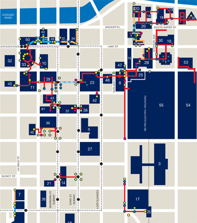
A few weeks ago I attended a Chicago community information meeting for residents of the wards impacted by the structural end-of-life of the Western Avenue overpass. This elevated stretch of roadway runs about 1,000 feet and allows motorists traveling north-south on Western to bypass the light at Belmont and Clybourn. It was originally designed to divert traffic away from the crowds that formed at this intersection, the entrance to the once-great Riverview Amusement Park.
This viaduct forms part of the western edge of the neighborhood I live in. Like much road infrastructure built in the middle of last century, it needs to come down for reasons of material fatigue. The question is whether to rebuild or try something different. The goal of the informational meeting was to express the city’s point of view in a project to build an at-grade intersection where the viaduct now stands.


Like the Central Artery/Rose Kennedy Greenway, much of the environment around the viaduct has responded in the last fifty years by remaking itself into something that no longer needs the pedestrian interaction that so characterized the amusement park intersection before the overpass. One side is big box retail and expansive parking lots (and a massive police station); the other is a somewhat shady assemblage of businesses and residences that do not invite chance inquiry or, if they do, are playing precisely off the hidden nature of their facades (i.e., Underbar and The Viaduct Theater). Adaptability reigns.
The session was eye-opening personally, bringing together local residents, three aldermen, and the engineering firm hired to survey the options. Set up like a science fair project, representatives from the firm were stationed at a dozen or so posters that started with the problem and ended with the proposed solution.
If you have made it this far in the post you will not be surprised to learn that I favor the deconstruction of the overpass. So I was amazed to hear residents ardently supporting it, not for any transportation benefit it afforded them (a good portion of neighborhood residents must drive out of their way simply to get on it), but for the barrier it forms on the edge of the neighborhood. They preferred the way the wall of concrete prevents people from “cutting through” side streets. Other motorists, presumably not neighborhood residents, loved the unimpeded travel, so rare anywhere in the city. Though how much travel time one can save going 1,000 feet over surface traffic causes one to wonder about perception versus reality.

Infographic from the Western Avenue Corridor Improvement Project
The engineering firm wondered this too and offered the above illustration of projected travel times for the two options, in table form below. (Both are projections because a rebuilt overpass will conform to new standard widths and have different characteristics than the current roadway.)
| overpass | boulevard | |
| northbound | 7:50 | 6:00 |
| southbound | 6:20 | 4:30 |
Clearly the data shows that travel times will improve in new at-grade boulevard, right? Well, yes, but even putting aside the opaque methodology and lack of current travel times in the chart, there are so many factors that were not quantified on the chart as to make it suspect. What happens to the non-arterial street traffic? How might travel times at this intersection be affected by the much more substantial plans for diverting (even burying) the intersection at Fullerton/Elston/Damen? With a newly human-scale intersection, have inevitable slow-downs caused by pedestrians been included in the calculations? Perhaps all of these have been accounted for, but it wasn’t obvious and, most importantly, the data isn’t easily reviewable by the public at large.
I’m still all for tearing down this blight, but I’m less convinced the method of community engagement deserves praise. Few people who held one conviction left with a different one when the meeting concluded and the city was, in the end, free to proceed with its plans (should funding avail itself).
There’s a better way and I believe it can found upon the fertile middle-ground between urban planners and interaction designers — the two communities of practice not noted for close ties at the outset of this post.
We’ve got more data about cities than we know what to do with. It’s lying in archives, published on government websites, being sensed from instrumentation in the environment, deduced from aerial imagery, and built from the ground-up by citizens updating, tweeting, and texting a kind of pointillist painting of city life.
There’s simply no reason that we can’t design tools to bring city-dwellers into a closer relationship with information that can inform their choices. All the raw materials are there: data, visualization, analytics, and tools for socializing one’s insight or commentary. This would not obviate the need for town hall meetings or public presentation of a city’s plans, but it would equalize the power imbalance, bringing a Jacobsian emergent planning ethic to a suasive critical mass that can interact with top-down planning around a common set of facts.
I’ll close by outright quoting Adam Greenfield, a voice in the field of networked urbanism whose echoes you’ve heard throughout this post.
I’ve always taught my students that if you scratch a New Yorker, you’ll find a committed urbanist — someone with intense and deeply-held opinions about the kind of trees that ought to be planted along the sidewalks, or the right way to organize bike parking, or ways to reconcile the conflicting needs of dogwalkers and parents with children in city parks. And the same thing, of course, is true of Mancunians, Singaporeans and Cariocas.
The point isn’t that all of their notions are going to be fair, practical, practicable or even remotely sensible, but that an immense body of pragmatic insight and — more importantly, in my view — passion for the city is going untapped. Pundits, bobbins and bureaucrats talk constantly about improving the efficiency of municipal services, but if improved information is a driver of that efficiency, why aren’t we even trying to gather all the incredibly rich data that’s just lying there, more or less literally begging us to use it? We have the tools, we have the models, we know what they’re good for and where they fall down. It’s past time to build on this experience and bring its lessons to bear on the places we live.
Past time for sure. But not long now.
——–
Further reading:
Frameworks for citizen responsiveness, enhanced: Toward a read/write urbanism, Adam Greenfield.
Highways to Boulevards, Congress for New Urbanism.
The Information Architecture of Cities, Andrew Coward and Nikos A. Salingaros.
Planning for Cars in Cities: Planners, Engineers, and Freeways in the 20th Century, Brian Taylor et al.
Rethinking Urban Freeways, Mark de la Vergne and Anuj Bhandari.
Metropolitan Information Architecture and other mouthfuls

Returning to my info design roots this weekend as I give a talk at the IA Summit in Phoenix on city design. But this one’s a bit different. It’s a call to arms, the other half of a talk I gave last year to architects of the physically-built environment. I’ll be presenting with my grad school colleague and pal, Don Turnbull. Here’s his preview and the full details. UPDATE: Here’s audio from the talk and our slides.
Stretching a bit further, I will be speaking at the Metropolitan Planning Council of Chicago on April 21 on a panel called Talking the Walk: The Importance of Pedestrian-Friendly Public Spaces. I’m honored to share 90 minutes with Sam Schwartz and -Joe Gonzalez- Mike Toolis and am fully prepared for quizzical looks as I try to explain the importance of walkability from the perspective of information network design. Full details here. UPDATE: Recap here.
PS – Mouths-full?
SXSW panel preview: The City Is A Platform
Time for the annual pilgrimage to Austin for South By Southwest. I’ve been on panels before but, with zero disrespect to previous co-panelists, the one I have currently lined up is going to be really freaking good, maybe the best ever. Here’s detail.
Tuesday, March 16
11:00 AM
Room 9ABC
Austin Convention Center
[Add to my.sxsw.com or sitby.us.]
The panel is a great cross-section of perspective on networked urbanism. We got non-profit, academia, start-up, city government, and faceless mega-corporation (me).
Ben Berkowitz runs SeeClickFix.com, a tool that allows communities to report non-emergency issues to those responsible for the public space. This app has changed the conversation around civic engagement and prompted a number of municipalities to rethink their 311 strategy. Also, NPR likes it.
Assaf Biderman is the Assistant Director of the SENSEable City Lab at MIT. The work from the lab itself is amazing (flying LED robots, trash-tracking, city bikes that are also environmental sensors!), but it also approaches art, having been featured at the Venice Bienalle, Centre Pompidou, and Ars Electronica. Also, he’s the suavest panel member.
Dustin Haisler is the CIO and Administrative Judge for the City of Manor, Texas. Words can’t do justice to the amazingness that is Dustin. But a link might. He’s just completely rewritten the rules of city governance and engagement. Also, he’s younger than you.
Jen Masengarb is an Education Specialist at the Chicago Architecture Foundation where she educates the public about cities and the built environment. Jen gets what it takes to translate the urban world for its citizens and is a template for how we might do so in our second cities of data. Also, she’s the femalest member of the panel.
And then, me, of course. I’m just stewarding the awesome above.
We’re going to tackle three question areas, broadly.
- What is the physically-built urban environment’s relationship to the digital environment that is being built atop it? Put another way, is there a mandate for information architects to be thinking as critically about cities as they do about websites?
- What is the design imperative: how do we train the makers of today to think about the city as a platform?
- What is the role of citizens in this design? This is different than focus groups and user studies. Citizens shape the machine that is the city in completely indirect and informal ways.
If you’ll be in Austin for South by Southwest — and you’re hanging around until the last day of Interactive — I’ll bet you a taco and a beer you’ll learn something from this panel.
Recap post and podcast to follow.
Off the grid
BLDGBLOG has a wonderful post up comparing the way the building in the original Die Hard movie is used by the hero John McClane in every way except how it was designed to be used.
McClane explores the tower—called Nakatomi Plaza—via elevator shafts and air ducts, crashing through windows from the outside-in and shooting open the locks of rooftop doorways. If there is not a corridor, he makes one; if there is not an opening, there will be soon.
It’s a great essay, especially as it explores the real-world tactic [PDF] of Israeli troops who move through urban theaters by carving a path through the walls of adjacent buildings to remain unseen from the air or the street. (There’s also a fascinating digression on the way the new Bourne films use the city as a kind of weapon itself, contrasted with cities as mere setting for the gadget-dependent James Bond.)
But the main thrust of the piece comes from Die Hard: “[McClane’s] is an infrastructure of nearly uninhibited movement within the material structure of the building.”
This is the idea of the building as a network. And it scales up.
Our networked technologies already give us this sense of “uninhibited movement” within information space. If we consider the book an architectonic form (the Latin stanza means “room” after all) we see the emergence of the same dynamic of a decade ago when hypertext came into popular consciousness. Hyperlinks and unique IP addresses allowed us relatively uninhibited movement through a landscape of information, jumping to and fro, outside the linearity of the millennia-old codex.
I think what BLDGBLOG is pointing out are the cinematic imaginings — and military exigencies — that prefigure the way we increasingly think of the networked urban space as a mutable environment that can be bent to our will. It isn’t uninhibited in the truest sense (there are still walls to be destroyed or network outages to be dealt with), but barriers to movement are less dictated by the grid of streets and buildings than governed by another layer of experience, grounded in data and sensors.
Kazys Varnelis makes this point in another, powerful way:
In this condition of total urbanity, maps as navigational tools for the physical traversal of space are supplanted by intelligent maps for navigating a contemporary space in which the physical becomes a layer of data in a global informational space. If that space is created by society, it is also a space that, in its massive complexity, has become unknown to us, a second nature simultaneously also a second city and the space in which today’s identities are being formed. Much of this world is invisible and it is the task of the designer to help us understand it.
Intelligent maps — and a least a small number of films — help us think of the city as a platform for our own uses, related to but not wholly confined by the way it was physically built.
The physical city grid is vital, but even before networks and mobile technologies came to be the grid was made permeable by human need. Consider the Chicago Pedway. It’s an official but disjointed way of maneuvering through the central business district, initially constructed to give people a way of moving around safe from the elements. The Pedway is a series of tunnels and bridges that allow covered movement, wholly apart from the grid of streets and sidewalks. Desires lines, it seems, can sometimes be concretized. (As many of the diagonals is city street grids attest. Diagonals are often some of the earliest routes in the area showing human movement along paths of least resistance — or animal trails — that pre-date major settlement.)
There are thousands of other ways of moving through the dense city space that are, for now, merely habitual paths inside the heads of city pedestrians. Shortcuts through alleys, building lobbies, detours through subway connectors, or just routes that align with well-covered sidewalks. It is only a matter of time before these crowd-sourced paths of least resistance are made available via the network. (We’ve seen it in experiments like the “paths of least surveillance”, which of course is why the Israeli army does what it does.)
Of course, all dense, diverse urban areas would have walkscores of 100 if one could walk through walls. But we can’t and I’m not advocating the build-out of a completely porous physical environment or a LEGO-style recombinant cityscape. (Mark Z. Danielewski’s Tardis-like House of Leaves depicts one creepy end of this particular vector.) Constraint is as important as mutability. What’s physically available is as important as the ability to get to it.
But our concept of the city — what we can do with it — has changed because of the layer of networking and data that co-exists with it. Certainly ease of movement is increased, as is the act of information gathering (about nearby friends, businesses, and resources). But this is the low-hanging fruit. The real opportunity, it seems to me, comes from the analogy of the move from printed information to networked information: the ability we’ve been given to write to the space as well as read from it. Living in an architecture of information, we can more easily participate in its construction than we can with the physically built-environment. This is our right, if not a kind of civic duty for the information age. (More on this topic in a future post.)
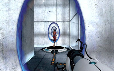
The video game Portal is interesting to consider as a kind of embodiment of a mutable environment environment that still partakes of rigorous constraint. In Portal you move about a highly orthogonal, multi-room architected space with a gun that can blast “entry” and “exit” portals — basically teleporters. You can’t create portals just anywhere, though, and often you’ve link yourself into a corner. It’s surprisingly fun (and good for kids who like blasting things, minus the carnage). The point, I think, is that there’s a certain deep human satisfaction in carving one’s own path, bending a physical space to one’s own needs. Portal, like our tools of networked urbanism, succeeds by meeting that basic human desire.
BLDGBLOG makes the point that the Die Hard sequels would not have gotten progressively worse if they had not abandoned the simple premise of a hero who uses a physical space to his own ends, suggesting that scaling Nakatomi plaza up to the level of a city in future installments would have been the logical (and entertaining) next step. I don’t disagree, but we don’t need Hollywood to do it for us. The city of information is being built, piecemeal, by the lived experience of its human actors everyday, an elaborate movie set overlaid on a functioning city street.
Our second city
Recently I was asked by WBEZ, the Chicago NPR affiliate, to write an essay on a topic or trend from 2009 that I would like to see carried forward “from here on out”.
What I wrote was a condensation of a year of conferences and talks informed by IBM’s Smarter Cities perspective — all with a Chicago bent. It was an interesting and ultimately enjoyable exercise, whittling down a tough subject into something to be read aloud. I’m grateful to NPR for the opportunity and their collaborative editing.
Here’s the link to the transcript and audio on NPR. The actual broadcast, I’m told, will be during All Things Considered on 1/1/2010. Pretty sure the broadcast is Chicago-only.
Here is the original essay, which gives a little more context to my screed.
This past year offered Chicagoans some unique opportunities to consider our collective identity as a city. We looked forward, dreaming of how we might remake the urban space to host the world and its Olympians in 2016. We looked backward, celebrating Burnham’s 100-year-old vision for what the city might become and, perhaps more interestingly, what it never did become. These two events both asked Chicagoans to imagine a city that did not exist, to grapple with a series of what-ifs about the built environment.
And yet, there’s another city — equally intangible — being built even as we move on from the Olympic decision and unrealized bold plans. It is a literal second city, built right atop our architecture of buildings, streets, and sewers. This is the city of data — every bit as complex and vital as our physical infrastructure, but as seemingly unreal (and unrealized) as the what-might-have-beens of Burnham’s Plan and Chicago 2016.
But what is a city of data and why should Chicago care about being one?
IT research firm Gartner notes that by the end 2012, 20% of the (non-video) data on the Internet will originate not from humans but from sensors in the environment. If your eyes just glazed over, let’s look at this from a different angle: if Gartner is right, for every four text messages that a pedestrian sends, the sidewalk she is walking on while doing so is also sending an equivalent amount of data. The city itself is becoming part of the Internet.
This is happening already. The city is increasingly instrumented; nearly everything today can be monitored, measured, and sensed. There are billions of processors embedded in everything from structural girders to running shoes. Millions of radio frequency identification tags turn inanimate objects into addressable resources. The city is immersed in a environment of data continuously built and rebuilt from the lived experiences of its occupants. And yet, this information architecture is hardly planned, much less dreamt about, or celebrated.
Consider the intersection of Michigan Avenue and Congress Parkway, what Burnham envisioned as a grand pedestrian-friendly concourse leading westward towards a towering civic center and eastward to the lakefront. This was never built, of course. (The circle interchange is our civic center, alas.) And yet there’s another built world, equally intangible, an infrastructure of data, overlaid on this intersection.
- Three students surf the web thanks to an open WIFI cloud that leaks out of a local hotel lobby.
- Several GPS units in cars all update with detail about the intersection as they approach.
- Sensors embedded in the water main below the street register a blockage.
- Closed-circuit cameras in three different shops capture the same window shopper as he moves down Michigan towards Randolph.
- An exhausted cyclist’s bike computer uploads his location and energy expenditure as he stops to use his iPhone to log into a Zipcar waiting to take him home.
- The city 311 database is populated with 7 different service requests from the surrounding area, coming from phone and e-mail.
- Taxis criss-cross the intersection as their fare data trails are logged locally and broadcast to dispatch.
- Four different people tweet from different perspectives on the same news crawl that moves across a building’s frontage.
- A bus stops to pick up passengers and bathes them in the glow of the full-color video screen running along its side.
- RFID chips on pallets loaded into building docks beneath the street respond to transducers in the receivers’ doorways.
And on and on. The examples are commonplace, but together they form an infrastructure — or superstructure — a second set of interactions, invisible or barely visible, atop the interactions that we plan for and currently build for. Proprietary, public, local, remote — all manner of data continuously permeates the streetscape. And yet we scarcely think of how it plays a part in the city that we’re building, the city that we want to become.
We don’t dwell on physical city infrastructure much either — unless we’re momentarily captivated by an architectural facade or, more commonly, inconvenienced by some lapse in the expected service. And yet. We’re the city that defines architectural styles for the world, that elevates an urban planner to local celebrity, that engages in a heated debate about the merits of remaking ourselves for the Olympics. From here on out why should we not apply such passion to the next wave of digital infrastructure? It is a decision not to be made lightly or as a thought exercise: how we design our city of information is as vital to quality of life as streets, schools, and job opportunity.
Dan Hill, a leading urban designer in matters digital, notes that we often think of the information landscape like street furniture and road signs, as adornment or a supplement to the physical environment. But fissures in a city’s data infrastructure are as consequential as potholes. They are structural failings of a city at the most basic level, in a way that a busted piece of street art would never be.
Think of cell phone outages — “dark zones” — as potholes in the urban information landscape. Or consider GPS brownouts, such as cause error in bus-tracking when the CTA enters the satellite-blocking skyscraper canyon of the Loop. But these examples are minor compared to the real issue before us: how do we proactively build a city of information that is inclusionary, robust but flexible, and reflective of a city’s unique character?
Our built structures — physical and digital — are manifestations of the patterns of human life in a city. They encode our desires, our needs, and our hopes. In some cases the permanence of the built environment inhibits or works at cross-purposes to these goals. (Think of expressways as barriers to the way people move about neighborhoods.)
We have a unique opportunity to ensure that our digital infrastructure avoids the mistakes of our physical infrastructure, to make Chicago the envy not just of building architects but of information architects.
I suggest two ways to start. To engage in a dialogue about this new built environment — such as we did collectively this summer — our city planners and citizenry need to be at least as conversant with the language of information architecture as we are, at a basic level, about physical architecture. Call it an aesthetics of data. This is as much a matter of becoming aware of what’s happening around us, of figuring out the most elegant ways of making the unseen felt, of thinking of our urban spaces as I described the interactions at Michigan and Congress.
Second, we need to recognize that, while the power of information is the power to connect, every linkage made represents a connection not made or, at worst, a disconnection. (Think again of the unintended effects of expressways on neighborhood mobility.) Our plan for a networked urbanism should seek above all to be maximally enfranchising, lowering barriers to commerce and community.
We must take up this mantle and be active participants in the design of this networked urbanism. We must make our voice heard. From educating our elected representatives about the opportunities before us, to encouraging our youth — who increasingly live in a world of data — to think critically about their role in the urban fabric, we must embrace this challenge with the same passion embodied in our historical tradition of remarkable plans for Chicago.
[This essay is cross-posted at the Building a Smarter Planet blog.]
My Year of the City
If my years had titles, like the Chinese lunar calendar, this would be The Year of the City.
October, 2008: I was in Beijing1 to launch the Virtual Forbidden City, a multi-user 3D world recreation of the famous palace complex. It was the end of many years of immersion in the design of a special kind of city. Seems almost preordained in hindsight, but this was my primer in designing an environment of information atop a traditional “built” environment. A kind of sandboxed proving ground for urban augmentation.
But things were about to change. The economy hit the skids, the US elected a new president, and IBM’s Smarter Planet (and Smarter Cities) strategy was just taking off.
Something else happened at the end of last year. For the first time in history more human beings lived in urban areas than not. (It is a trend with momentum: by 2050 more than 70% of the world’s population will live in metropolitan areas.)2 Recession or not, it was clear that cities were going to be the nodes for effecting the most change — social, economic, and environmental.
Closer to home, my own city was taking a hard look at itself — both how it had lived up to what it wanted to be and how it could be something different in the future. Fresh from the glow of sending one of our own to the White House (and before that was dimmed by an idiot governor), the city began a year of celebrating the 100th anniversary of The Plan of Chicago by Daniel Burnham and John Root.
Workshops, concerts, exhibits, tours, dramatizations, even a luminous, gilled pavilion by Zaha Hadid — all commemorations of this seminal document. But the real effect was to focus the city on itself, to look closely, critically, and comparatively at what had been done in a century and what might still be.
Of course, this self-awareness was magnified by the competition for the 2016 Olympic games. Our bid spurred much discussion, much dissent, and not a little hope that we’d be able to add a fifth star to the city flag.
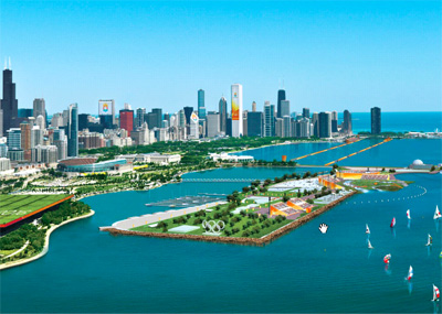
The bid book was a vision of a city re-imagined from the lakefront inward, a big plan to stir hearts, our own virtual city.
But it too was forbidden, and the games were awarded to Rio de Janeiro. (Maybe there’s still a chance?)
This has been a professional year of great upheaval for me. Lots of changes, nearly all for the better, at work. But change is change, and it’s been tough to establish new rhythms. Worth it, though, as I’m helming a most fascinating exploration of cities called City Forward. Though it lacks rocket ships, it may be the most perfect merger of personal passion and professional pursuit I’ve yet experienced. (Psst, Mayor Daley: spaceport on the lake!)
The pace is set now. I’ve spoken at some great conferences, and I’m gearing up to bring it full circle as part of the Bold Plans For the Next 100 Years panel at the Chicago Humanities Festival: Burnham Centennial Program on Nov. 14. (Looking forward to City Camp in Chicago and a possible panel at SXSW too.)
So if you’re urban-averse, like huge cars and suburban commutes, or otherwise think the metropolis is an earthly hell, fair warning. There’s gonna be a lot of city talk in this neighborhood in the coming year.
——–
1 My last trip out of the country and the first time in a decade that I’ve been so domestic. Dopplr mocks me.
2 United Nations Department of Economic and Social Affairs, Population Division, World Urbanization Prospects, 2007. [PDF report]
Mission Elapsed Time: 20:00:21:06:42:40

I went back through it this blog (and my Flickr account) on its 20th anniversary, retracing digital footprints made on what feels like a different planet. Here are some highlights.
The Ampcamper

How I hauled myself, two teens, an 80 lb dog, and a whole load of crap 4000+ miles across six states in twenty days using an electric vehicle. And survived to tell the tale.
The Terror Tourist

Explorations of place in horror fiction — real or imagined, geographical or psychological — culled from my time on The Heavy Leather Horror Show 2023-2026.
Subscribe to the podcast or the email newsletter or just read through the archives posted here.


