Giftmix 2013 (Holiday Edition)
As 2013 winds down it is time for the annual reliving-making-cassette-mixes-for-friends moment. It’s really for me. I’m unwilling to give up on that visceral joy of stitching tunes together as a gift. However, this year, instead of mashing up music that my family enjoyed during the preceding year I’m giving in to listener feedback and actually posting holiday music.
This particular half hour comes from a fun evening of back-and-forth joint DJ’ing the OpenGovChicago Holiday Party on Dec. 12 with DJ C, aka Jake Trussell. Jake’s set is not online, but his warmup is.
Holiday Tunes Past, Future and Which Should Never Have Been by Immerito on Mixcloud
Very best to you in 2014!
10,000
I’m coming up on my tenth anniversary as a Flickr user and just posted my 10,000th photo. Actually it is not a photo but a short clip of the CTA Holiday Train rolling in to Belmont station on the Purple Line. I’m especially pleased with a fairly useful application of the iPhone 5S slow-motion video: though the train is coming in quickly, you get to see St. Nick nice and clear.
Flickr has been through the ringer in the last few years. Yahoo has not been kind. And the changes since Marissa Mayer has taken over, while positive in that Flickr is getting attention, leave me scratching my head a bit. Yet, Flickr contains the memories of my last decade and I still don’t know of another service that offers the kind of tools that the site does. I’ll be with Flickr until the end — mine or its. (Backing up frequently of course).
Lost in Space, Ascent Stage edition
Got the urge to muck with the Lost in Space theme recently. I loved the re-runs of that show growing up (and have deliberately forgotten that a movie was made of it in the 90’s). The theme I used began with the show’s third season.
The title track is tiny, just one minute long with an unfortunate or awesome (your pick) Austin Powers breakdown in the middle, so there wasn’t much to work with. The arpeggios are emblematically spacey to me so I ran with that. I replaced The Robot with Siri, the panicky AI of our time (especially when using Apple Maps).
I really should embed this on this site’s 404 page.
What the public way means in the networked age
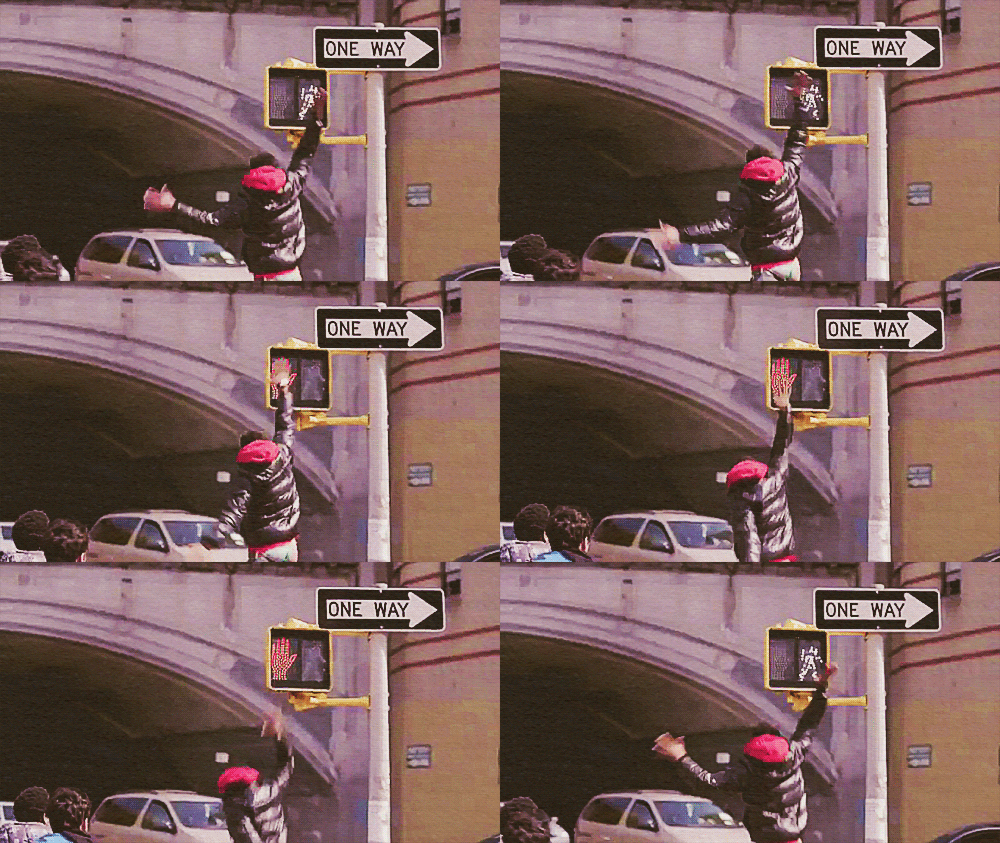
Let’s start here. I want our relationship with public objects to feel like this.

It does not feel like this currently.
But let’s back up to a street scene in Chicago in the late 1930’s for context.
You’re walking at a clip downtown because it’s storming. You hunch over and tilt your umbrella into the sheeting rain as people scamper for cover and taxis. Luckily your destination is this building and you know, thanks to having walked this route before (and a clever architect), that you don’t even have to look up to figure out that you’ve arrived.
On both the Clark and LaSalle sides of the Field Building (as it was originally known) are symbols in the sidewalk pointing to the entrances. F for Field, arrows for which way to turn.

If noticed at all, these small, plain sidewalk icons could easily be mistaken for architectural decoration. But they were designed specifically around the umbrella use-case.
You may also have seen compass markings in the sidewalk just as you step out of a subway stop. Easy to overlook, but incredibly useful if you’re disoriented emerging onto the surface grid.
These examples represent embedded, passive information that’s not screaming for attention but placed precisely where you might need it. It’s information design in the physical architecture of the public way.
Today there’s a new usage scenario. You’ve seen it a thousand times. Urban pedestrians staring down at their smartphones, half-in and half-out of the moment in what Amber Case calls “temporarily negotiated private space”.
Maybe the F-marks would be missed by these otherwise engrossed city-goers, but they are a great example of ambient information in city environments. And we’re going to need a lot more of that as we increasingly negotiate our public space through a mixture of physical and digital awareness.
What’s new is the sheer volume of mobile, networked technology in our public spaces (and everywhere else). It’s an opportunity to “embed” information in new ways and to customize it to very specific places and moments in time.
Typically sensors and wireless connectivity claim the spotlight in discussions of the networked city, but I’d argue we’re missing a real opportunity not to use new technology to make the built environment more legible.
Why?
Most obviously, embedded digital information can aid in safety. The video of the girl in China on the phone falling through the sidewalk is one end of a spectrum of examples, most of which are instances of obliviously texting pedestrians falling off piers, walking into traffic, or smashing into one another. And it’s probably getting worse.
Rudimentary systems that might prevent such calamity do exist, but with a focus on motorist, rather than pedestrian, alertness at crosswalks. Crosswalks and Xwalk both flash lights to make the zebra stripes more prominent. You could imagine a more nuanced system which assumes pedestrians are looking down (at their devices) and flashes or changes color when the traffic signal is about to turn green. Interaction with devices via Bluetooth or NFC is not inconceivable either. Scenario: if the device is engaged in use, assume distraction, and alert accordingly. A responsive public way that’s in a positive feedback loop with its users.
Accessibility is another category of use for the responsive public way. Crosswalk design for the visually-impaired is not a problem for individual intersections — high-pitched chirping signals — but it doesn’t scale for large cities. The cacophony of a city full of bleating traffic signals would be the kind of noise pollution that causes New York City to impose fines on honking motorists. But if the crosswalk itself was open to digital development you could imagine white canes, phones or other personal devices alerting the visually-impaired pedestrian that the street was open to cross.
Basic convenience may be an even better rationale for a legible (and writable) public way. Why perform a digital transaction at a modern-day parking meter when you can text it or use an app to pay before leaving your car? Think driving snowstorm. Think having three kids in the backseat and the meter is 100 meters away. Think not having a credit card at all. All good reasons. This is getting closer to the high-five moment of a digital public way.
If we begin to think of a truly responsive public way we have to rethink what “public” means in the digital age. The analogy here is a city’s information. Getting at a city’s vital signs and the records of public servants has been a long slog for transparency advocates. In the days of exclusively paper-based record-keeping Freedom of Information legislation was one of the only ways to do anything with public records. Then came digitization and the same barriers obtained. You had to go through legal maneuvers to get at it — and even then it was not particularly useful beyond reading it. PDF’s largely made this information static, opaque to computer-aided parsing and tabulation. But the advent of machine-readable online document standards and a shifting political climate towards the value of open government has unlocked torrents of data in cities around the world. What’s come of this can only be described as a new kind of civic engagement: open data has bred an ecosystem of secondary applications, analysis, and interactions that governments could never conceive of, much less produce themselves.
The infrastructure and objects of our current public way are in their paper period.
Certainly, there are screens scattered throughout. Public transit leads the way here. Buses that generate location data, subway platforms that announce arrival times, etc. There’s some digital marketing along the way that occasionally serves up alerts or public service announcements. And every so often you’ll see an advertiser attempt something (barely) interactive — a QR code for more information, typically. But there’s no platform in the software and open data API sense of the word in the physical city.
And yet, many of our public objects are networked — the foundational requirement for a responsive system. Public bikes and bike stations, bus shelters, parking meters, and of course every light pole with a public access point clamped to it — all these things are network endpoints. But they’re not interconnected and they are not open to interaction. There’s no interface for third-party development.
Some City of Chicago Department of Transportation construction projects feature NFC and QR codes on signage onsite that link to information about the project. That’s the paper stage, incunabula. The vision is for direct access to mobile-optimized applications for business permits in situ. More promisingly, the information system underlying the upcoming roll-out of public bike sharing in Chicago (e.g., real-time bike availability info) has an open API. 4,000 bikes and 400 stations will be open to development and interaction in the way that the city’s open data portal is. A step away from paper towards platform.
There’s an inverse to this dynamic, equally ripe with opportunity. The impact of city-dwellers’ use of digital technology when out-and-about has yet to make a any real impact on physical urban design. Mayor Nutter of Philadelphia got a good laugh last year when he released an April Fools Day video touting newly-striped “texting lanes” on sidewalks. But that was parody (though thinking about it a little longer makes it slightly less parodic).
Surpassingly few cities and urban design firms actually give thought to how technology is changing the way the city is used. Which is odd, since so many of the problems that online companies grapple with — what it takes to create a vibrant, safe public space, as one example — have pretty well been solved, if not perfected in implementation. There’s the Facebook approach, which is essentially suburbia: a gated network of affinity that disallows chance encounter and serendipity. And there’s the Twitter approach which is all about non-reciprocal engagement and diversity. (It’s no coincidence that the founder of Twitter is a dilettante urbanist.) This is a choice between mall culture and real urbanism and I fear that our information architects and built environment architects have not even begun the conversation.
The sidewalk is the original social network and its lessons have much to teach the designers of our digital overlay of public spaces.
In Chicago, it’s coming together: a robust open government community of engaged developers (and increasingly savvy residents) fueled by an administration actively publishing data and working to make sure the vendors of our public objects treat it as a platform. There’s a long way to go, but we’ve etched some symbols in the pavement and we’re hoping you follow our lead.
High five!
(X * X = Chicago). Solve for X.

Recently, as we sometimes do to fill time, my family and I were asking each other trivia questions. My six-year-old daughter piped up with one from left field that made me laugh out loud — then had us thinking for the rest of the evening. She asked:
What’s the square root of Chicago?
Didn’t have an answer for that one, but it was ready-made for my Twitter followers and they did not disappoint.
The literalists looked at ranking and square mileage, but perhaps this town if squared might be us:
@immerito it’s Sunbury, North Carolina population 1,645
— Zach Kaplan (@zkaplan) February 17, 2013
Some took a geographic angle. Logan Square, the Loop itself and my favorite:
@immerito Fort Dearborn. It was a square. Planted the roots of our city. twitter.com/tomkompare/sta…
— tom kompare (@tomkompare) February 18, 2013
The most interesting approach was formulated by Seth Lavin. He put it two ways:
For the verbal minds, it’s whatever makes this sentence true: “In Chicago, we blank blank.” (e.g. we reform reform)
In other words, (X * X = Chicago). Solve for X?
It’s a head-scratching formulation, in some ways. What thing, what action, what verb does Chicago do to the same thing, action, verb that makes this city uniquely us?
Some suggestions:
- defeat defeat
- discriminating discriminators
- perfect perfection
- disempower disempowerment
- build buildings
- plant plants
- bully bullies
- reform reform
- red line (huh?)
No clear winner to my mind, but I sure did like Josh Davison’s wordplay: “polish Polish”. As in polish off Polish sausage. My wife noted that the reverse has been historically true with Polish housekeepers being employed to polish things (among other tasks).
All good fun, of course, but this exercise may be an epiphenonemon of the very real debate over whether cities can be mathematically described in a useful way. That’s quite another post. For now let’s revel in the oddball question of a six-year-old kid.
Giftmix 2012
Keeping the flame alive, here’s the year-end giftmix. You know the drill. It ain’t the best of 2012 and it’s barely generically coherent, but these are the tracks that either (a) made people on the dancefloor happy at Beat Research Chicago or (b) were in one way or another special to my family this year. (You’ll gather that I took my son to his first concert, Roger Waters doing the entirety of The Wall this year, for instance.) Hope you enjoy.
Tolva Giftmix 2012 by Immerito on Mixcloud
In The Flesh? – Pink Floyd
Flutes (Sasha Remix) – Hot Chip
Chime/Crime (Live in Australia) – Orbital
Sweet Thing (Adam Faz Dub Remix) – Tenor Fly & Dreadsquad
Whiskers – Gemini & Feed Me
Breakn’ A Sweat (Zedd Remix) – Skrillex & The Doors
Random – Gary Numan
Puttin’ On The Ritz (Club Des Belugas Remix) – Fred Astaire
Keep Pounding – Mooqee & Pimpsoul
Baby Battle Scratch – Lemon Jelly
Good Gone – K Theory
Ana Ng – They Might Be Giants
Debaser – Pixies
Bohemian Rhapsody – Queen
The Trial – Pink Floyd
Outside the Wall – Pink Floyd
Full stream at Mixcloud, above. MP3 for download here.
Happy holidays and a healthy, propserous new year to you all!
Scorched wheat
In 2007, as my parents and I were exploring the area around my family’s home town in southern Italy, we drove through an ominous stretch of landscape. It was Illinois farmland meets Mauna Loa, cropland burning as neat lines of flame munched what remained of threshed wheat into soil-enriching ash.
It’s an image that stuck with me, reminding me of the controlled burns my family does to its prairie in Galena, IL and adding an eerie atmosphere to what might be my favorite photo of the volcano Vulture on whose slope our ancestral village sits.
Turns out a minor culinary trend has been sparked by what we saw. La Cucina Italiana recently featured the pasta possibilities from Grano arso (“burnt grain”), specifically from Puglia (just north of where we were in Italy). It’s basically toasted wheat, but the explanation of the tradition is fascinating. It’s said that “burnt” pasta dates to a time when land-owning nobility would allow peasants to scour the fields after a wheat harvest (and burn-down). Blackened grains would be collected for a literal poor-man’s pasta. Alternate versions of the origin of this pasta state that poor workers would sweep up the milling room floor for crumbs, toasting what they gathered, or simply take the remaining burnt flour from the decks of bread ovens.

If you’re hardcore and want to scorch your own wheat for pasta-making, I applaud you. We did not do that, as at least one importer sells it.
The taste? Imagine an al dente version of a nicely toasted pizza crust. Yummy. We made an incredibly simple dish from it — essentially orecchiette, broccoli, pepperoncini, and garlic — and it was a flavor-bomb. (Here’s the recipe we used.)
So, yeah, if you’re in to off-beat Italian pastas, I’m here to recommend grano arso. Perfect winter tastiness.
Negril, Jamaica
May 2012. Eight couples of college friends all turning 40 this year, a 16th wedding anniversary, rum, reefs, and a commemorative mix of reggae and its descendants, below.


We kept the spirit alive with a dinner party this weekend after returning home. Jamaican theme, of course.
- Shellfish watermelon ceviche (with scallops and shrimp, photo below)
- Jerk vegetables (summer squash, zucchini and mushrooms) and chicken skewers
- Red snapper in coconut curry broth
- Coconut lime rice
- Avocado, orange and goat cheese salad
- Appleton rum cake
- Mango sorbet
- Rum cream over ice

Full photo set here.
Drums keep pounding a rhythm to the brain
Mix from last night’s always-enjoyable overlap of Beat Research and Urban Geek Drinks. A few older tracks (and a K-TEL easter egg) laced into the stew. Enjoy.
Supertramp on the brain
I just realized I love Supertramp and always have. WTF. What else do Ilove that I don’t know that I do?
— John Tolva (@Immerito) March 21, 2012
Really the only way to get this out of my head was to mess with it.
Done.


